Pete Kauhanen

Pete Kauhanen, MA
Senior GIS Manager
Environmental Informatics Program
Geographic Information Systems
510-746-7370
Pete Kauhanen is an experienced environmental scientist, planner, UAS expert, GIS specialist and manager with well over 10 years' experience generating, obtaining, and analyzing GIS data for environmental projects. He has a background in watershed ecology, green infrastructure planning, habitat mapping, fire management, promoting indigenous knowledge to address conservation goals, as well as large and small scale mitigation and conservation projects and initiatives. He earned both his MA and BA from Stanford University where his studies focused on ecology, behavioral ecology and using GIS to study environmental anthropology. For his Masters thesis he created a 10 year fire history for a section of the Western Desert of Australia to highlight the effects of the Australian Aboriginal Martu people on local ecology, habitat types, and predictive capabilities for biodiversity. His findings resulted in changing the prescribed burn policy of Western Australia’s Department for Environmental Conservation and have broad implications for fire management and climate change adaptation. Most recently, Pete has been utilizing UAS (or drones) in order to map and model wetlands and other natural resources in order to address issues such as erosion, wetland health and trash quantification. Pete continues to bring his GIS experience to bear on projects where scientific research intersects policy and management decisions.
Related Projects, News, and Events
 Preparing for the Storm (Project)
Catalyzed by the extensive damages caused by the Winter 2016-2017 storms and the opportunity to align flood response with major habitat improvement, Preparing for the Storm is an innovative public-private partnership to improve watershed health and resilience in the Alameda Creek watershed.
 Baylands Habitat Map 2020 (Project)
The Baylands Habitat Map 2020 updates the existing map of tidal marsh, tidal flats and diked baylands and incorporates the many changes in baylands distribution and abundance that have occurred over the last two decades. It also includes new information about land use and infrastructure that affects baylands restoration and management constraints and opportunities. To ensure the map is as up-to-date as possible, the project will develop procedures for ongoing local updates and change detection to cost-effectively maintain the basemap’s high value.
 California Aquatic Resource Inventory (CARI) (Project)
The California Aquatic Resources Inventory (CARI) is a Geographic Information System (GIS) based map of wetlands, streams, and riparian areas within California that is hosted online through EcoAtlas.
 Mapping Outside the Box: Visualizing Bay Landscapes in New Dimensions (News)
The most recent meeting of the San Francisco Estuary Geospatial Workgroup featured Pete Kauhanen and Lindsey Sim of SFEI's Environmental program. This meeting focused on emerging technologies for visualizing the changing Bay around us. Presenters discussed new data, tools, and approaches that are helping inform regional natural resource management.
 Vision from the Skies: Using UAS Surveys to Monitor a Key Restoration Project (News)
At the McCosker Creek Restoration site, 3,000 linear feet of creek channel that previously had been flowing through underground culverts since the 1950s was daylighted and reconstructed. In addition, invasive and non native plants were removed and replaced with over 5,000 native plants. The restoration was also designed to support erosion control, and provide habitat for wildlife and aquatic species including rainbow trout, California red-legged frog and the Alameda whipsnake. This restoration work began in 2020 and concluded in 2023.
 California Trash Monitoring Methods Project (Project)
The California Ocean Protection Council (OPC), in close partnership with the State Water Board, has recognized the importance of standard methods for trash monitoring and has funded this project. The Southern California Coastal Water Research Project (SCCWRP) and San Francisco Bay Estuary Institute (SFEI) have partnered up to test multiple trash monitoring methods with a goal of developing a library of methods with known levels of precision, accuracy, and cross-comparability of results, and linking these methods to specific management questions.
 Delta Aquatic Resource Inventory (Project)
DARI is the Delta Aquatic Resources Inventory of surface waters, wetlands and other aquatic resources in the Sacramento-San Joaquin Delta (Delta). The goal of the DARI project is to develop a geospatial inventory of aquatic resources that will be used as a common base map for the Delta. A similar mapping approach used to create the California Aquatic Resource Inventory (CARI) will be applied to provide a map of the aquatic resources and their associated attributes.
 Next Generation Urban Greening (Project)
SFEI is working with partners across the Bay Area to design tools to help cities achieve biodiversity, stormwater, and climate benefits through multifunctional green infrastructure.
 Blue Carbon Science to Support Climate Action (Project)
Working with other scientists, agency staff, and regional and state-level managers and planners, we are building alignment and capacity for blue carbon quantification through science synthesis, outreach, and mapping.
The Riparian Zone Estimator Tool (RipZET) is a decision support tool developed by the San Francisco Estuary Institute and Aquatic Science Center for the California Riparian Habitat Joint Venture and the California Water Resources Control Board to assist in the visualization and characterization of riparian areas in the watershed context.
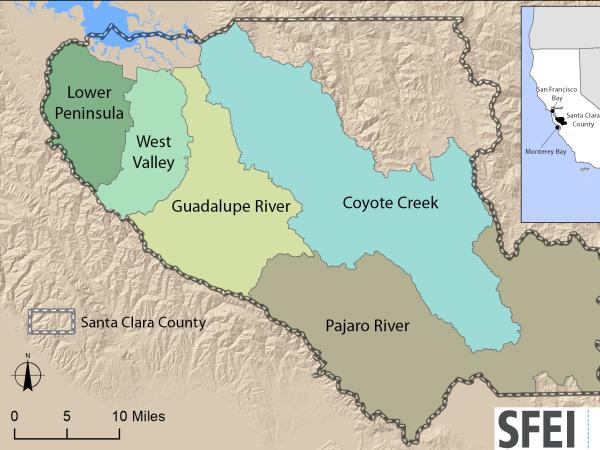 Santa Clara Valley Water District Priority D5 Project's Watershed Condition Assessments (2010 to present) (Project)
https://www.valleywater.org/project-updates/2012-d5-ecological-data-collection-and-analysisSFEI and the Santa Clara Valley Water District's (Valley Water) Priority D-5 Project have been conducting baseline ecological condition assessments in Santa Clara County, CA to characterize the distribution and abundance of stream and wetlands in five major watersheds, and to assess the overall ecological conditions of streams in the watersheds based on the California Rapic Assessment Method for streams (CRAM). The surveys employ the state's recommended Wetland and Riparian Area Monitoring Plan's watershed aproach that includes the use of GIS-base maps of aquatice resources (BAARI), and spatially-balanced ambient stream condition surveys using CRAM.
 Tahoe WRAMP Demonstration: Watershed Assessment (Project)
The Tahoe WRAMP Watershed Demonstration Project transferred statewide wetland monitoring and assessment tools to Sierra Nevada environmental agencies and organizations by conducting a pilot study that evaluated the distribution and abundance of wetlands, and the overall ecological condition of streams in two watersheds within the Lake Tahoe Basin.
, Dee Shea Himes (R)") Healthy Watersheds Resilient Baylands (Project)
Healthy Watersheds Resilient Baylands (Project)
Through the EPA-funded Healthy Watersheds Resilient Baylands project, SFEI and sixteen partner organizations are developing multi-benefit tools to enhance climate change resilience in San Francisco Bay. Healthy Watersheds Resilient Baylands has two major components: Multi-benefit Urban Greening and Tidal Wetlands Restoration. Through both components, we have developed strategies that inform policy, planning, and design of innovative implementation projects.
 Coastal Wetlands, Beaches and Watersheds Inventory (Project)
The Ocean Protection Council (OPC) and SFEI will develop an inventory of the wetlands and other surface waters of all California’s coastal HUC-8 watersheds, including the inland Delta of the San Francisco Estuary, to help implement the OPC’s 2020-2025 Strategic Plan. The inventory will include a dashboard and other online tools that enable the OPC and the public to track progress towards multiple O
 A Bird's Eye View on Bay Area Marshes (via Unoccupied Aerial Systems) Yields New Insights (News)
SFEI continues to leverage our Unoccupied Aerial Systems (UAS) capabilities to support conservation and monitoring efforts around the Bay. Two recent projects include monitoring for the Sears Point Restoration Project in San Pablo Bay, as well as conducting a number of flights to support the US Environmental Protection Agency (USEPA) filming of existing marshes and marsh restoration projects that help protect both communities and critical infrastructure.
 Bay Area Aquatic Resource Inventory (BAARI) (Project)
The Bay Area Aquatic Resources Inventory (BAARI) is a GIS base map of the Bay Area's wetlands, open water, streams, ditches, tidal marshes and flats, and riparian areas. BAARI was developed using standardized mapping protocols to ensure that the level of detail and wetland classification system is standardized across the region.
 Russian River Regional Monitoring Program: Comprehensive Basemap of Surface Waters and Riparian Areas (Project)
This project will build on existing projects funded by the CA State Water Board, Ocean Protection Council, Sonoma Ecology Center, and Sonoma County to produce a basemap of aquatic resources, using the updated Standard Operating Procedures (SOP) of the California Aquatic Resource Inventory (CARI), including at-risk waters and their riparian areas, to support the Russian River Regional Monitoring Program (R3MP). The main tasks of the project are to:
") Vernal Pool Habitat Restoration and Protection CRAM Tools for the Central Valley, CA (Project)
Vernal Pool Habitat Restoration and Protection CRAM Tools for the Central Valley, CA (Project)
The California Wetland Program Plan (WPP) seeks to strengthen protection for wetlands in many ways, including building capacity to track the net benefits of wetland policies and programs by employing aspects of the State’s Wetlands and Riparian Area Monitoring Plan (WRAMP).
 New Delta Habitat Map! (News)
The Delta Aquatic Resource Inventory (DARI) is a map of surface waters, wetlands and other aquatic resources in the Sacramento-San Joaquin Delta. A similar mapping approach used to create the Bay Area Aquatic Resource Inventory (BAARI) was applied to complete a consistent map across the larger San Francisco Estuary. Both DARI and BAARI are integrated into the California Aquatic Resource Inventory (CARI), which serves as the basemap in EcoAtlas.
 Trees, Hydrology, Urban-Greening, and Nature-Based Solutions (News)
Two key reports support nature-based solutions. Green stormwater infrastructure (GSI) and enhancements to the urban tree canopy offer benefits to stormwater management, urban ecological improvements, and complementary urban greening activities.
On KGO TV, these projects were featured on July 1, 2021.
- 1 of 4
- next ›