Enhanced Landscape Profile Modes in EcoAtlas deliver new insights
Mar 9, 2024
EcoAtlas is a mapping and geographic data visualization tool that continues to evolve to meet emerging needs. The toolset now includes new data layers and summaries to support the watershed planning, tracking, and reporting needs for the state. Within EcoAtlas, the Landscape Profile Tool provides easy access to summaries and data visualizations on watershed characteristics, ecological condition, habitat connectivity, and coastal habitats for an area of interest. The improved design and addition of customized profiles make it straightforward for EcoAtlas users to generate a landscape profile best suited to tracking progress towards programmatic objectives.
The summarized watershed information can be used to develop a Watershed Profile that complies with Water Board requirements for proposed restoration projects or mitigation for dredge or fill projects. A Watershed Profile is a compilation of information on the abundance, diversity, and condition of aquatic resources in a project evaluation area and is used to evaluate the impacts of a project and help define watershed goals. More information on how to generate a Watershed Profile.
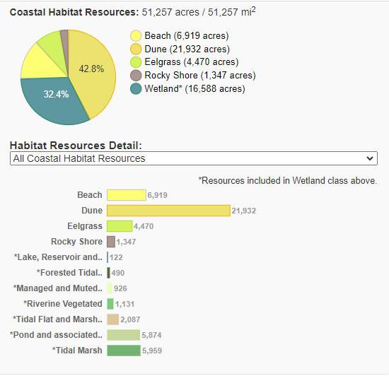
New customized profiles summarize baseline acreages of priority coastal habitats (beach, dune, eelgrass, and rocky shore) within the coastal zone regions or by hydrologic region and help track progress towards multiple targets identified in the Ocean Protection Council’s Strategic Plan to protect California’s coast and ocean. Generate a Coastal Habitat Profile.
The Condition Profile includes a new section on Riparian Management that summarizes watershed prioritization recommended actions to support the protection of streams and associated riparian habitats across California. Recommended management actions for a stream reach include the categories of Protect; Risk Reduction; Restoration; Management; and Restoration and Management. More information on the modeled riparian management actions.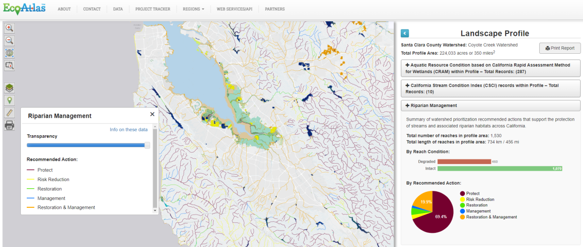
Associated Staff:
Other Contributors:
Sree Gopal, OPC
Justine Kimball, OPC
Kevin OConnor, CCWG
Eric Stein, SCCWRP
Rafi Mazor, SCCWRP
Programs and Focus Areas:
Software Engineering
Wetland Monitoring & Assessment
Related Projects, News, and Events:
 EcoAtlas (Project)
EcoAtlas is a set of tools for generating, assembling, storing, visualizing, sharing, and reporting environmental data and information.
 EcoAtlas’ Landscape Profile Tool v2.0 (News)
The recent EcoAtlas release delivers new functionality and enhancements to the Landscape Profiler, a tool that summarizes ecological information at various spatial scales for assessment, planning, and reporting. Users can upload a KML file, edit the boundary, and save a polygon for their area of interest. Additional datasets are summarized in the Landscape Profile Report, including the revised 2011 National Land Cover Dataset, eelgrass survey data along the coast from Humboldt Bay to San Diego Bay, and percentages of languages spoken from the US Census data.
 New data layers and Landscape Profile mode added to EcoAtlas (News)
New data layers and Landscape Profile mode have been added to EcoAtlas (ecoatlas.org), an online tool for visualizing the abundance, diversity, and condition of wetlands, along with the project activities that are affecting the landscape. Enhancements include: