Library
Our library features many hundreds of entries.
To search among them, click "Search" below to pull down options, including filtering by document type, author, year, and keyword.
Find these options under "Show only items where." Or you can also sort by author, title, type, and year clicking the headings below.
Export 1849 results:
Filters: Filter is [Clear All Filters]
2024. Microplastics Monitoring and Science Strategy for San Francisco Bay 2024 Revision. SFEI Contribution No. 1144. San Francisco Estuary Institute: Richmond, CA.
2018. Blurred lines: Multiple freshwater and marine algal toxins at the land-sea interface of San Francisco Bay, California. Harmful Algae 73, 138-147 . SFEI Contribution No. 875.
2020. Summary of Water Year 2017 precipitation, discharge, and sediment conditions at selected locations in Arroyo de la Laguna watershed, with a focus on Arroyo Mocho. SFEI Contribution No. 912. San Francisco Estuary Institute: Richmond, CA.
This report summarizes the precipitation, discharge, and sediment conditions observed from October 1, 2016 to September 30th, 2017 (Water Year (WY) 2017) in the Arroyo de la Laguna watershed, with a focus on the Arroyo Mocho watershed. This information was collected by the Zone 7 Water Agency to support operation and maintenance of their flood control facilities. Additionally, this and similar information collected in WY 2018 and 2019 will be utilized to update the Arroyo Mocho watershed sediment budget (Pearce et al, 2020).
2009. A Sediment Budget for Two Reaches of Alameda Creek: support for flood control channel management.
2023. Arroyo de la Laguna: Reach-based Geomorphic Evaluation. Prepared for the US Environmental Protection Agency’s Water Quality Improvement Fund. SFEI Contribution No. 936. San Francisco Estuary Institute: Richmond, CA.
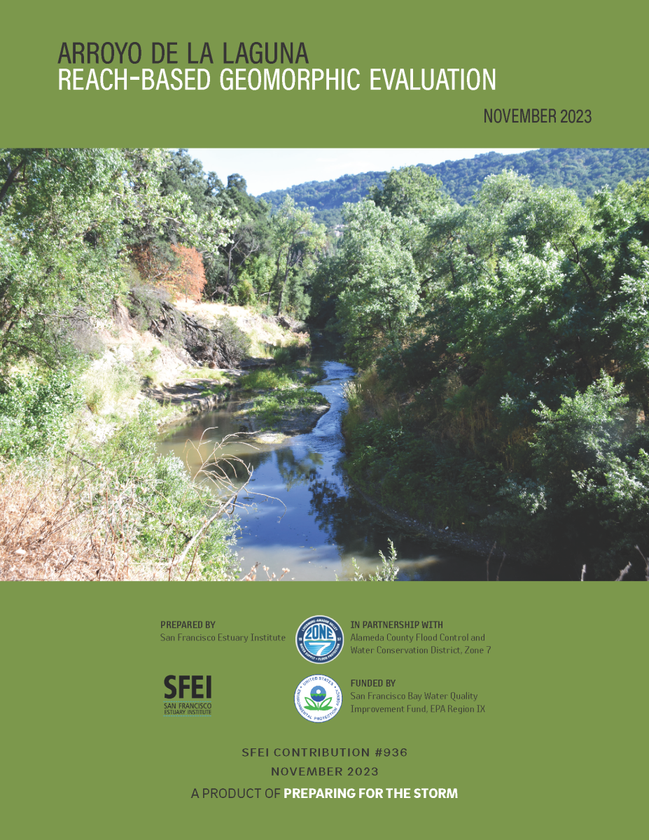 The reach of ADLL between the Arroyo Del Valle confluence (at the Interstate 680 crossing) and Verona Road is currently experiencing significant changes to its channel morphology, namely incision and widening, leading to bank erosion and bank failures. Many of the parcels adjacent to the stream channel are experiencing loss of property and damage or loss of some bank-top structures. The complex history of this reach makes it difficult to determine the current and future condition and functioning. In an effort to understand the ADLL geomorphic processes and channel evolutionary pathway, Zone 7 has partnered with SFEI to create this Reach-based Geomorphic Evaluation report that will serve as a reference for the historical, current, and likely future condition of the reach, and will provide broader context to inform decisions about potential restoration projects.
2023. Translating Sediment Science Into Action: Documenting Beneficial Sediment Reuse. SFEI Contribution No. 1124. San Francisco Estuary Institute: Richmond, CA.
 The Preparing for the Storm project, led by Zone 7 Water Agency (Zone 7) and funded by the US Environmental Protection Agency (EPA) Water Quality Improvement Fund, aims to develop science-based plans, strengthen existing and new partnerships, and pilot new methodologies for tackling these issues surrounding coarse sediment. As a task within this larger project, this report describes four projects in the East Bay that serve as case studies for beneficial reuse of sediment. Each example highlights a project with sediment that could be reused (in lieu of landfilling) or a project that needs additional sediment and could benefit from deliveries of sediment that normally would not have been beneficially reused.
2021. Towards a Coarse Sediment Strategy for the Bay Area. SFEI Contribution No. 1032. San Francisco Estuary Institute: Richmond, CA.
Historic and current regional management of watersheds and channels for water supply and flood control across the San Francisco Bay Area has cut off much of the coarse sediment that was historically delivered to the Bay. Here we define coarse sediment as having grain sizes larger than 0.0625 mm, which includes sand, gravel and even cobble, as opposed to fine sediment that includes clay, mud and silt. Future projections indicate that sediment supply will not meet the demand from extant and restored tidal marshes to keep up with sea level rise.
The US EPA Water Quality Improvement Fund Preparing for the Storm grant has funded the Zone 7
Water Agency, the San Francisco Estuary Institute and the San Francisco Bay Joint Venture to support
the future development of a successful regional coarse sediment reuse strategy. Development of
such a strategy requires an understanding of logistical and regulatory hurdles and identification of key
strategies for breaking down barriers. One potential solution for meeting the sediment demand along
the Bay margin is to utilize coarse sediment that is removed from flood control channels by public
agencies. To-date, very little of this sediment that is removed is beneficially reused for restoration
along the Bay shoreline. The current economic and regulatory framework around sediment removal
presents many challenges, barriers and lack of incentives for agencies to reuse their sediment.
This document represents a step forward towards beneficially reusing coarse flood control channel sediment by outlining reuse challenges, and identifying incentives for participation and potential solutions.
2023. McCosker Creek Restoration and Public Access Project: Alder Creek Daylighting Additional Monitoring Elements - Final Report. SFEI Contribution No. 1157. San Francisco Estuary Institute: Richmond, CA.
2009. Alameda Creek Bulk Sediment Study Technical Memorandum. San Francisco Estuary Institute: Oakland,Ca.
2004. Relative effects of fluvial processes and historical land use on channel morphology in three sub-basins, Napa River basin, California, USA. IAHS, International Association of Hydrological Sciences 288.
2023. Sycamore Alluvial Woodland Restoration and Enhancement Suitability Study. In collaboration with Alameda County Flood Control and Water Conservation District, Zone 7. Prepared for the US Environmental Protection Agency’s Water Quality Improvement Fund. SFEI Contribution No. 1128. San Francisco Estuary Institute: Richmond, CA.
 The “Sycamore Alluvial Woodland Restoration and Enhancement Suitability Study” addresses distribution and regeneration patterns and restoration strategies of sycamore alluvial woodland (SAW) habitat, a unique and relatively rare native vegetation community adapted to California’s intermittent rivers and streams. The report was produced by SFEI and H. T. Harvey & Associates, as part of the US EPA Water Quality Improvement Fund Preparing for the Storm grant, led by Zone 7 Water Agency.
2015. Sediment Supply, deposition, and transport in the Flood Control Facilities of Arroyo Mocho and Arroyo Las Positas from 2006-2014. . SFEI Contribution No. 771. San Francisco Estuary Institue: Richmond, CA.
2024. Petaluma River Watershed Contemporary Riparian Condition Assessment. Petaluma River Watershed Contemporary Riparian Condition Assessment. SFEI Contribution No. 1160. San Francisco Estuary Institute: Richmond, CA.
2008. RMP Sediment TIE Study 2007-2008: Using Toxicity Identification Evaluation (TIE)Methods to Investigate Causes of Sediment Toxicity to Amphipods. SFEI Contribution No. 561. San Francisco Estuary Institute: Oakland, CA.
1988. Executive Summary of the Monitoring of Toxic Contaminants in the San Francisco Bay-Delta: A Crtical Review. SFEI Contribution No. 151. San Francisco Estuary Institue: Richmond, CA. p 14.
1988. Monitoring of Toxic Contaminants in the San Francisco Bay-Delta: A Critical Review, Emphasizing Spatial and Temporal Trend Monitoring. SFEI Contribution No. 153. AHI: Richmond, CA. p 244.
2001. Sediment Toxicity Identification Evaluations San Francisco Bay RMP for Trace Substances - Progress Report. SFEI Contribution No. 46. San Francisco Estuary Institute: Richmond, CA.
1987. Toxic Contaminants in the San Francisco Bay-Delta and their Possible Biological Effects. SFEI Contribution No. 145. Aquatic Habitat Institute: Richmond, CA. p 472.
1987. The Screening of Problems Relating to the San Francisco Bay_Delta. SFEI Contribution No. 138. San Francisco Estuary Insitute: Richmond, CA. p 77.
1987. Executive Summary of Toxic Contaminats in the San Francisco Bay - Delta and Their Possible Biological Effects. SFEI Contribution No. 139. San Francisco Estuary Institute: Richmond, CA. p 15.
1988. Monitoring of Toxic Contaminants in the San Francisco Bay-Delta: A Critical Review. SFEI Contribution No. 152.
2011. RMP Sediment Study 2009-2010 Determining Causes of Sediment Toxicity in the San Francisco Estuary. SFEI Contribution No. 626. UC-Davis, Marine Pollutions Studies Laboratory.
2000. Investigations of Sediment Elutriate Toxicity at Three Estuarine Stations in San Francisco Bay, California. SFEI Contribution No. 374. San Francisco Estuary Institue: Richmond, CA.
2023. Regional Analysis of Potential Beneficial Use Locations. Conducted for the San Francisco Bay Regional Dredged Material Management Plan. Prepared by the San Francisco Estuary Institute for the US Army Corps of Engineers, San Francisco District. SFEI Contribution No. 1178. San Francisco Estuary Institute: Richmond, CA.
2023. Baylands Resilience Framework for San Francisco Bay: Wildlife Support. SFEI Contribution No. 1115. San Francisco Estuary Institute: Richmond, CA.
2022. Adaptation Pathways: San Leandro Operational Landscape Unit. SFEI Contribution No. 1077. San Francisco Estuary Institute: Richmond, CA.
. 2012. Historical Ecology of the McCormack-Williamson Tract: A Landscape Framework for Restoration. SFEI Contribution No. 674. Aquatic Science Center / San Francisco Estuary: Richmond, CA.
. 2007. 2007 RMP Annual Monitoring Results. SFEI Contribution No. 572. San Francisco Estuary Institute: Oakland, CA.
. 2014. 2012 Annual Monitoring Results. San Francisco Estuary Institute: Richmond, CA.
. 2006. RMP Benthic Assessment Workshop.
. 2007. 2006 RMP Annual Monitoring Results. SFEI Contribution No. 542. San Francisco Estuary Institute: Oakland.
. 2021. Simulating Sediment Flux Through the Golden Gate. Prepared for Regional Monitoring Program for Water Quality in San Francisco Bay (RMP). SFEI Contribution No. 1033. San Francisco Estuary Institute: Richmond, CA.
2004. Evaluation of Benthic Assessment Methodology in Southern California Bays and San Francisco Bay. Southern California Coastal Water Research Project: Westminster. CA.
2011. Apparent Tolerance of Common Tern (Sterna hirundo) Embryos to a Pentabrominated Diphenyl Ether Mixture (DE-71). USGS-Patuxent Wildlife Research Center: Beltsville, Maryland.
2013. Comparative embryotoxicity of a pentabrominated diphenyl ether mixture to common terns (Sterna hirundo) and American kestrels (Falco sparverius). Chemosphere 93 (2), 441-447.
2020. Restoration Vision for the Laguna de Santa Rosa. SFEI Contribution No. 983. SFEI: Richmond, CA.
The Laguna de Santa Rosa, located in the Russian River watershed in Sonoma County, CA, is an expansive freshwater wetland complex that hosts a rich diversity of plant and wildlife species, many of which are federally or state listed as threatened, endangered, or species of special concern. The Laguna is also home to a thriving agricultural community that depends on the land for its livelihood. Since the mid-19th century, development within the Laguna and its surrounding watershed have had a considerable impact on the landscape, affecting both wildlife and people. Compared to pre-development conditions, the Laguna currently experiences increased stormwater runoff and flooding, increased delivery and accumulation of fine sediment and nutrients, spread of problematic invasive species, and decreased habitat for native fish and wildlife species. Predicted changes in future precipitation patterns and summertime air temperatures, combined with expanding development pressure, could exacerbate these problems. People who manage land and regulate land management decisions in and around the Laguna, including landowners; federal, state, and local agencies; and local stakeholders, are seeking a long-term management approach for the Laguna that improves conditions for the wildlife and people that call the Laguna home. The California Department of Fish and Wildlife and Sonoma Water funded the Laguna-Mark West Creek Watershed Master Restoration Planning Project to develop such a management approach, focusing on the need to identify restoration and management actions that enhance desired ecological functions of the Laguna, while also supporting the area’s agriculture and its local residents.
2018. Resilient Landscape Vision for Upper Penitencia Creek. SFEI Contribution No. 894. San Francisco Estuary Institute - Aquatic Science Center: Richmond, CA.
2010. Petaluma River Impairment Assessment for Nutrients, Sediment/Siltation, and Pathogens Part 1: Existing Information and TMDL Comparison. Aquatic Science Center: Oakland.
2007. Critical Coastal Areas Program, Phase I Final Report. SFEI Contribution No. 541. San Francisco Estuary Institute.
2010. Indicators and Performance Measures for North Bay Watersheds. San Francisco Estuary Institute: Oakland, Ca.
2007. Appendix 1: All Deliverables Submitted for the Critical Coastal Areas Program, Phase I. San Francisco Estuary Institute.
2009. Calibration and evaluation of five indicators of benthic community condition in two California bay and estuary habitats. Marine Pollution Bulletin 59 (1-3), 5-13.
. 2017. 2017 RMP Multi-Year Plan. San Francisco Estuary Institute: Richmond, CA.
. 2011. 2011 Annual Monitoring Results: A report of the Regional Monitoring Program for Water Quality in the San Francisco Estuary. San Francisco Estuary Institute.
. 2017. 2017 RMP Detailed Workplan and Budget. San Francisco Estuary Institute: Richmond, CA.
2015. 2015 RMP Multi-Year Plan. San Francisco Estuary Institute: Richmond, CA.
2015. 2015 RMP Detailed Workplan. San Francisco Estuary Institute: Richmond, CA.
2015. 2015 RMP Program Plan. San Francisco Estuary Institute: Richmond, CA.
. 2016. 2016 RMP Multi-Year Plan. San Francisco Estuary Institute: Richmond, CA.
. 2016. 2016 RMP Detailed Workplan and Budget. San Francisco Estuary Institue: Richmond, CA.
2014. A Delta Transformed: Ecological Functions, Spatial Metrics, and Landscape Change in the Sacramento-San Joaquin Delta. SFEI Contribution No. 729. San Francisco Estuary Institute - Aquatic Science Center: Richmond, CA.
2016. A Delta Renewed: A Guide to Science-Based Ecological Restoration in the Sacramento-San Joaquin Delta. Delta Landscapes Project. Prepared for the California Department of Fish and Wildlife and Ecosystem Restoration Program. A Report of SFEI-ASC’s Resilient Landscapes Program. SFEI Contribution No. 799. San Francisco Estuary Institute - Aquatic Science Center: Richmond, CA.
This report offers guidance for creating and maintaining landscapes in the Sacramento-San Joaquin Delta that support desired ecological functions, while retaining the overall agricultural character and water-supply service of the region. Based on extensive research into how the Delta functioned historically, how it has changed, and how it is likely to evolve, we discuss where and how to re-establish the dynamic natural processes that can sustain native Delta habitats and wildlife into the future. The approach, building on work others have piloted and championed, is to restore or emulate natural processes where possible, establish an appropriate mosaic of habitat types at the landscape scale, use multi-benefit management strategies to increase support for native species in agricultural and urban areas, and allow the Delta to adapt to future uncertainties of climate change, levee failure, and human population growth. With this approach, it will be critical to integrate ecological improvements with the human landscape: a robust agricultural economy, water infrastructure and diversions, and urbanized areas. Strategic restoration that builds on the history and ecology of the region can contribute to the strong sense of place and recreational value of the Delta.
Printed copies of the report are available for purchase.
2014. North Bay Mercury Biosentinel Project (December 2014 Report). SFEI Contribution No. 738. San Francisco Estuary Institute: Richmond, CA.
2016. Primary Production in the Sacramento-San Joaquin Delta: A Science Strategy to Quantify Change and Identify Future Potential. SFEI Contribution No. 781.
2017. Delta Landscapes Executive Summary. SFEI Contribution No. 853.
2022. Delta Wetland Futures: Tidal Marsh Resilience to Sea Level Rise. SFEI Contribution No. 1106. San Francisco Estuary Institute: Richmond, CA.
. 2015. Vision for a Resilient Silicon Valley Landscape. SFEI Contribution No. 753.
2017. Delta Landscapes: A Delta Renewed User Guide. SFEI Contribution No. 854.
A Delta Renewed User Guide aims to increase the accessibility of the technical findings in A Delta Renewed for easier application to restoration and conservation efforts across the Delta. The recommendations in A Delta Renewed focus on landscape-scale ecological guidance. We present three examples of how the information in A Delta Renewed might be used to address different management and restoration questions. Because of the complexity of the Delta system, this guide does not address all possible questions and does not replace the need for detailed, site-specific data and expertise. Rather, it shows how the information in A Delta Renewed might provide a common foundation for restoration planning.
The User Guide was written for a broad audience, including restoration practitioners, landowners, and local, state and federal agencies. The guide provides a step-by-step path through A Delta Renewed; a user is walked through how to apply the findings of the report via a series of steps to address each of the three restoration and management questions. This process is intended to help the user access regionally-specific recommendations and strategies to plan and manage future Delta landscapes that can support desired ecological functions over the long term.
The goal of A Delta Renewed and this guide is not to recreate the Delta of the past. Rather, the objective is to understand how we can re-establish or mimic important natural processes and patterns within this altered system to support desirable ecological functions (such as healthy native fish populations, a productive food web, and support for endangered species), now and into the future.
2018. North Bay Mercury Biosentinel Project: 2016 - 2017. SFEI Contribution No. 868.
2020. Think Global, Act Local: Local Knowledge Is Critical to Inform Positive Change When It Comes to Microplastics. Environmental Science & Technology . SFEI Contribution No. 1024.
Microplastic contamination in the marine environment is a global issue. Across the world, policies at the national and international level are needed to facilitate the scale of change needed to tackle this significant problem. However, sources and patterns of plastic contamination vary around the world, and the most pressing actions differ from one location to another. Therefore, local policies are a critical part of the solution; recognizing local sources will enable mitigations with measurable impacts. Here, we highlight how investigating the contamination comprehensively in one location can inform relevant mitigation strategies that can be transferred globally. We examine the San Francisco Bay in California, USA—the largest estuary on the West Coast of the Americas, and home to over 7 million people. The local contamination of microplastics in surface water, sediments, and fish from this urban bay is reportedly higher than many places studied to date.(1) This example demonstrates the value of local monitoring in identifying sources, informing local mitigation strategies and developing an array of solutions to stem the multifaceted tide of plastic pollution entering our global oceans.
2005. Levels and Distribution of Polybrominated Diphenyl Ethers in Water, Surface Sediments, and Bivalves from the San Francisco Estuary. Environmental Science & Technology 39, 33-41 . SFEI Contribution No. 310.
2021. OPC Coastal Wetlands, Beaches and Watersheds Inventory Factsheet, March 2021th ed.
2002. Influence of Thermal Stratification on the Depth of Distribution of Pelagic Juvenile Rockfish of central California. Fishery Bulletin . SFEI Contribution No. 475.
2007. A review of total dissolved copper and its chemical speciation in San Francisco Bay, California. Environmental Research 105, 5-19.
2016. Contaminant Concentrations in Eggs of Double-crested Cormorants and Forster's Terns from San Francisco Bay: 2002-2012. SFEI Contribution No. 736.
2006. Polycyclic aromatic hydrocarbon (PAH) contamination in San Francisco Bay: A 10-year retrospective of monitoring in an urbanized estuary. Environmental Research 105, 101-118 . SFEI Contribution No. 492.
2007. Spatial and temporal variations in silver contamination and toxicity in San Francisco Bay. Environmental Research 105, 34-52.
2005. Polycyclic aromatic hydrocarbons in bivalves from the San Francisco estuary: Spatial distributions, temporal trends, and sources (1993–2001). Marine Environmental Research 60, 466-488 . SFEI Contribution No. 501.
2004. Polycyclic aromatic hydrocarbons in the San Francisco Estuary water column: Sources, spatial distributions, and temporal trends (1993-2001). Chemosphere 909-920 . SFEI Contribution No. 311.
2004. Polycyclic aromatic hydrocarbons in San Francisco Estuary sediments. Marine Chemistry 86, 169-184 . SFEI Contribution No. 82.
1998. Time Series of Suspended Solids Concentration, Salinity, Temperature, and Total Mercury Concentration in San Francsico Bay During Water Year 1998. SFEI Contribution No. 44.
1998. Technical Report of the San Francisco Estuary Regional Monitoring Program for Trace Substances. SFEI Contribution No. 375. San Francisco Estuary Institute: Richmond, CA.
2017. Passage of fiproles and imidacloprid from urban pest control uses through wastewater treatment plants in northern California. Environmental Toxicology and Chemistry 36, 1473-1482 . SFEI Contribution No. 783.
Urban pest control insecticides, specifically fipronil and its four major degradates (fipronil sulfone, sulfide, desulfinyl, and amide) and imidacloprid, were monitored during drought conditions in eight San Francisco Bay wastewater treatment plants (WWTPs). In influent and effluent, ubiquitous detections were obtained in units of ng/L for fipronil (13-88), fipronil sulfone (1-28), fipronil sulfide (1-5) and imidacloprid (58-306). In influent, 100% of imidacloprid and 62 ± 9% of total fiproles (fipronil and degradates) were present in the dissolved state, with the balance being bound to filter-removable particulates. Targeted insecticides persisted during wastewater treatment, regardless of treatment technology utilized (imidacloprid: 93 ± 17%; total fiproles: 65 ± 11%), with partitioning into sludge (3.7-151.1 μg/kg dry weight as fipronil) accounting for minor losses of total fiproles entering WWTPs. The load of total fiproles was fairly consistent across the facilities but fiprole speciation varied. This first regional study on fiprole and imidacloprid occurrences in raw and treated California sewage revealed ubiquity and marked persistence to conventional treatment of both phenylpyrazole and neonicotinoid compounds. Flea and tick control agents for pets are identified as potential sources of pesticides in sewage meriting further investigation and inclusion in chemical-specific risk assessments.
2015. The Tijuana River Valley: An Ecological Look into the Past.
Hot springs in the Tijuana River? Antelope by the beach? Zip-lines over the international border?
Come find out what the Tijuana River Valley looked like in the not-so-distant past and how the river, estuary, and surrounding areas have changed over the past two centuries. Hear how researchers “recreated” the historical landscape and how this information helps us to better plan for the future.
2017. Tijuana River Valley Historical Ecology Investigation. Prepared for the State Coastal Conservancy. A Report of SFEI-ASC’s Resilient Landscapes Program. SFEI Contribution No. 760. San Francisco Estuary Institute - Aquatic Science Center : Richmond, CA. p 230.
The Tijuana River Valley Historical Ecology Investigation addresses a regional data gap by reconstructing the landscape and ecosystem characteristics of the river valley prior to the major modifications of the late 19th and 20th centuries. The research presented here, funded by the California State Coastal Conservancy, supplies foundational information at the regional and system scale about how the Tijuana Estuary, River, and valley looked and functioned in the recent past, as well as how they have changed over time. The ultimate goal of this study is to provide a new tool and framework that, in combination with contemporary research and future projections, can support and guide ongoing restoration design, planning, and management efforts in the valley.
2016. Mission Bay Historical Ecology Reconnaissance Study: Data Collection Summary (Technical Report). SFEI Contribution No. 777.
The goals of the Mission Bay Historical Ecology Reconnaissance Study were to collect and compile high-priority historical
data about the Mission Bay landscape, identify sources that could help to develop a deeper understanding of early
ecological conditions, and to identify future possible research directions based on the available data. This technical
memorandum is intended to document the archives consulted during the reconnaissance study, summarize the collected
and compiled data, and to identify potential next steps. A separate technical presentation to project staff and advisors will
summarize the preliminary findings and questions generated from a review of the historical dataset. Ultimately, this
research is intended to support the San Diego Audubon Society’s Mission Bay Wetlands Conceptual Restoration Plan (CRP)
and the ReWild Mission Bay project.
2016. Ecological implications of modeled hydrodynamic changes in the upper San Francisco Estuary: Phase II Technical Memorandum. SFEI Contribution No. 786.
The physical and ecological environment of the upper San Francisco Estuary has been profoundly altered since the early 1800s. Recent efforts have utilized maps of the upper estuary’s historical habitat types to infer associated changes in desired ecosystem processes and functions. The work presented in this memo builds on these previous efforts, but utilizes a new tool for evaluating change over time: a 3D hydrodynamic model of the pre-development estuary. This model was constructed by Resource Management Associates (RMA) using a new digital elevation model of the pre-development upper estuary generated by SFEI and UC Davis (UCD) and “natural” boundary flows calculated by the California Department of Water Resources (CDWR).
Once completed and calibrated, the pre-development model was paired with a similar model of the contemporary system in order to analyze hydrodynamic changes in the upper estuary. These analyses are presented in a technical memorandum published by RMA (2015). This memorandum takes these analyses and considers the ecological implications of modeled changes (see the “Results” section). Hydrodynamic analyses include analyzing changes in tidal prism, isohaline positions, low-salinity zone habitat, channel velocity, and source water distribution.
In addition to describing the ecological implications of modeled hydrodynamic changes, this memorandum summarizes major ongoing questions about estuarine hydrodynamics that might be explored using these models, including changes in water residence time, temperature, transport pathways, and the connectivity of aquatic and semi-aquatic habitats. Understanding changes in these and other factors would greatly improve our understanding of the desirable ecosystem functions provided by the historical system and, as a result, improve our ability to recover these functions now and into the future.